Category Archives: Snowshoeing

Challenging Snowshoeing on the Brigus Head Path!

Hi folks, after last weekend’s defeat on the Mickeleen’s Path, I vowed I’d redeem myself on the Brigus Head Path loop. A 6.5 km moderately challenging hike with a bit of climbing and descending, and a much shorter couple of kilometers straight back over land, this trail is spectacularly beautiful in the summer months, and given our warm weather for the last week, I thought the snow would have likely taken a cutting. I was… partially right at best.

The snow had softened to be sure. That was not a good thing, however, as this trail is a bit of a wet one and the wet parts had undercut the snow, leading me to plunge to my knees on more than one occasion. In places the majority of last week’s snow remained untouched, which made for some treetop views and drift climbing. The soft snow gave me a workout, at least!

The first half of the trail from the north, up to the approach to Brigus Head, was very challenging. Lots of deep snow and more than once where I was unsure how to continue on the trail. After Brigus Head, the going got a little easier, the places where deep snow needed to be traversed were sporadic instead of constant. At the point where the trail meets with community trails, a quad or two had gone over the trail making the going a little easier, though they had messed up the muddy parts pretty good.

I turned around at the loop trail, not venturing all the way to the trailhead in Admirals Cove. The loop trail (the old road between Admirals Cove and Brigus South) followed the same pattern: easily passable for the first, uphill km or so, and then more challenging, essentially becoming a river interspersed with deep snow. Luckily, this is a short path and I was at the wharf next to the trailhead where I had parked in Brigus South before sundown.

If you’re in the mood for a challenge, this is one to consider. It’s hard to capture in pictures how deep the snow is and how tough it is to showshoe, but trust me, the rain has been a double-edged sword: clearing the trail in spots, it has simply softened things up in others. You might be better off waiting for a bit more of the snow to melt, but if you are willing to take it on, it’s certainly a unique experience at this time of year. Not for the faint of heart, let’s put it that way! Check out the pics of the exhausting but spectacular hike below!

Mickeleen’s Path Gets the Better of Me

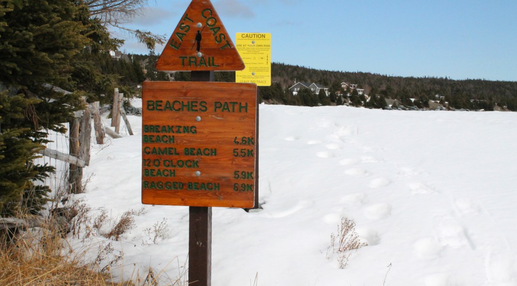
Hi folks! Excited about the prospect of a sunny Saturday with temperatures above zero, I had been planning all week to finish the trio of short Southern Shore hikes by heading out on the Mickeleens Path, but with the huge snowfall we received early in the week, I knew it would be a challenging walk. It turned out to be much tougher than I had anticipated!

I started a little late in the afternoon to complete the hike, but I figured that if the conditions were anything like those I had seen on the Beaches and Tinkers Point paths, I had tons of time. I quickly realized, given the conditions and the deep drifts, that I likely wouldn’t complete the Path today. I decided I’d do a chunk of it and head back along the path I created. At least one brave snowshoer had been on the trail in front of me. Many times I found myself thankful that I had footprints to follow and walk in.

That was true until the trail split. I followed what I thought the most likely route for Mickeleens Path, and I think it’s likely that the trail was followed for the most part, but the going was tough. There were places where the drifts were so high that I was climbing on a precarious slope at treetop level, and when the trail started winding around gulches at the 1.2 km point, I didn’t feel like it was safe to continue on my own, despite the tracks in front of me. At one of the final gulches the trail wound around the gulch a little too close for comfort, and so I decided I’d turn around and try the other trail.

When I got back to that point I noticed that there was indeed a ECT blaze on the tree. That was the first and last blaze I saw on either path, though. That’s something I think could be improved: in summer, it’s easy to follow the trail despite the scarcity of blazes (they’re reassuring but not necessary), but in the winter, any number of possible paths could be the right one, and more frequent blazes would help snowshoers find the path should they go astray. Sheesh! As if the trail volunteers don’t have enough work without keeping up with those of us crazy enough to be trekking the trails when there ARE no discernible trails!

Anyhow, the second path I took was obviously not the right one either. I took a break and checked my GPS: I was very close to the Old Track. I pressed onward and the snowshoe path took a right turn and eventually scrabbled through the bushes to the old track, where a snowmobile had beaten down an easily followed path to a point. I continued past this point for a while, but without a real destination, my plans for a loop completely dashed at this point, I used the deep snow beyond a clearing as an excuse to turn around and make my way back. I rejoined the ECT path just before the Mickeleens trailhead and made my way back to my vehicle at Quay’s Rd.

A short but exhausting trip! I don’t recommend Mickeleens Path in its current condition for folks who don’t know it well or who aren’t experienced snowshoers: it’s not an easy walk. For the brave, though, it’s an adventure! You beat me this time, Mickeleen, but I’ll be back! Check out the pics of crazy drifts in the gallery below!
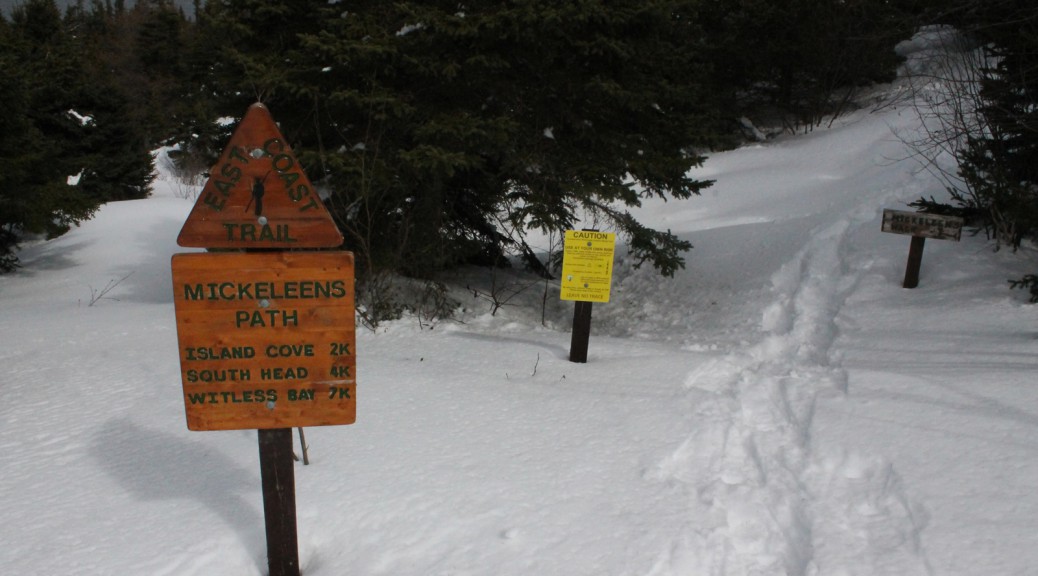
Weekend Snowshoe Trip to the Beaches Path!

Hi folks! It was bright and sunny for the most part yesterday, and I was ready to hike fairly early, so I figured I’d take advantage spend a few hours in the woods. I decided to snowshoe out over the beautiful Beaches Path between Witless Bay and Mobile. Hoping that the trail was in the shape that the neighboring Tinkers Point was in, I strapped on the snowshoes and headed out. As you can see from the pics, this trail required the snowshoes, and required a bit more trudging through snow than what I had seen on my other snowshoeing trips this spring! It was great fun, firing through the mostly unmarked snow past Breaking Point at the 2.8 km point. That made for 3.5 km or so of immaculate snow-covered trails through thick woods with little wind and the sun beating down: spectacular!

I made my way to the Mobile trailhead and headed back, which was made somewhat easier by following my own footprints through the soft spots. There were plenty of those, as the spring weather has started to soften up the wet spots. The places where plank bridges cross marshy areas are interesting tests on snowshoes, as they’re typically covered with pillars of snow. Crossing rivers and climbing stairs are definitely the bane of the spring snowshoer’s existence. There was deadfall at regular intervals as well, unfortunately: the volunteers have a bit of work ahead of them once the snow melts. Most are easily passable and the one that’s tough to climb can be detoured around.

The trail is easy to follow from start to finish, especially now that my big feet have been over it! I encourage you to get out and check it out… be cautious when the trail approaches hills and crosses rivers and you’ll be good! Check out the pics below!

First Hike of the Spring!

The first day of spring was two days ago, so that means the spring hiking season has begun! It’s still snowshoe season for the most part on the trails of Newfoundland, at least, especially in the woods. Given that it was going to be a bit breezy for Saturday’s hike, I decided to hike a section of the trail that had significant amounts of inland/wooded hiking, Tinkers Point Path. The trail was snow-covered and required snowshoes, but it was in such great shape that I’m sure it could mostly be negotiated in boots. At some point this winter a group of hikers traversed this path and beat down a spectacular track with their snowshoes; so good that for most of the Path it reminded me of the groomed snowmobile trails around St. Anthony on the Northern Peninsula!

The first section of the trail starts a little rough (I assume it gets a lot of use) but quickly settles into the “groomed trail” that covers 90% of the distance between Mobile and Tors Cove. The first bit, with the fence on one side and the coast on the other, has one spot that requires hikers take care; hug the fence and you’ll be fine. Exiting the woods for the first time, Marshy areas are starting to open up. The snowshoe trail in spots crosses areas that are becoming wet, so be careful. That said, sticking to it for the most part is safest: I deviated from it only a couple of times, and paid for it when I went through into a wet spot on the hike back.

Plenty of snow remains in the woods, but open areas such as Tinkers Point and Vales Meadow are pretty much free of snow aside from the established path where the snow was compacted. Speaking of Tinkers Point, the seas were very rough today, and crashed spectacularly against the rocks just off Tinkers Point. The section of the trail between Vales Meadow and the inland trek towards Tors Cove was very noisy with crashing waves. In a couple of places, a mini spout effect was created as water shot straight up against a barrier. Check out my pics!

I turned around at The Cribbies as per my agreement with Heather: I was not to snowshoe over the trail as it passes behind the fish plant in Tors Cove, a section with a precipitous drop. The Cribbies is close enough to the trailhead, I suppose!

I saw signs of wildlife, many gulls, a few small birds including juncos, and two bald eagles, one at either end of the Path. I got snowed on as a brief flurry passed over, but the weather was nice for most of the hike, with the sun coming out for the return trip. It was warm enough that I kept my jacket packed and my gloves off. I highly recommend this trail as a relatively easy spring snowshoeing adventure! Check out the pics below, and in the Tinkers Point Path page’s gallery!

Saturday Snowshoe at Blackhead Path!

Folks, yesterday was the first day that it wasn’t raining or snowing for almost a week, and it was a Saturday, perfect! Packed up the snowshoes and headed out to trek out and back over the Blackhead Path section of the East Coast Trail. The weather was fantastic, the trail was easy to follow except on the Blackhead (the community) side of the hike up to Blackhead (the bluff), where it was easy to lose but easy to pick back up.

I started in the afternoon, took a few snaps of the slob ice in the bottom of Blackhead Bay, walked just past the end of the private property before which the trail begins, and veered off course. For some reason, a rocky patch of the trail didn’t look like the right way, despite that I knew I hadn’t passed certain key points, including a patch I knew would be wet. I decided I’d follow another path that was combination snowmobile and snowshoe, it headed in the right direction after all. After some adventures which had me ankle deep in a river (saved by the Scarpas!), I rejoined the trail and managed to stick to it for the most part as I made my way up to Blackhead. I have a feeling the trail will be easier to follow in a few days since we’re looking at more rain and warm weather which should melt the snow currently covering the hill. That said, for the time being, it’d help to be familiar with the trail. It’s not likely you’d get lost, but keep an eye out for those trail marking poles on your way up the hill.

The trail was well defined and easy to follow from the top of Blackhead on for the most part. I passed a couple of hikers out enjoying the fine weather, coming from the other direction. Climbing down the other side of Blackhead through the woods was incredible. A grouse paid me a visit. Breaking out of the woods, there was a little bit of a chilly breeze as I walked the last few hundred metres to the trailhead at the edge of the Cape Spear Park property, but for the most part, I was toasty warm. I had my jacket packed and my hat and mitts off for a lot of the walk…

…which led to an unfortunate incident. I lost a black claw-style Swamy mitt somewhere between the other side of Blackhead and the viewpoint near the Cape Spear trailhead. I know, it’s only a glove, but I like these mitts, and I’d love to get it back if anyone spots it.

Anyhow, here are some pics I took! I’ll post these on the Blackhead Path page as well!

A Late Winter Hike at Cape Spear!

I’ve been on mid-term break all week and itching to get out for a little hike, but the weather has been uncooperative: I’m not one for extreme cold weather, and with wind chills dipping into the -30C range, I was waiting it out. Friday started promising, warming but windy, and knowing that I’d only be out for a couple of hours, I waited for the later part of the afternoon, when the temperature got up to -4C. It was still pretty windy, but once I got into the shelter of the woods at the start of the Cape Spear Path, it was a wonderful snowshoe trip! My goal was Staffordside, or at least the branch that leads to the valley, but I left it too late, and given my lack of exercise this winter, it was probably for the best… snowshoeing is hard work at times! I turned around as the path climbs the ridge over Sharks Point at about the 4 km point (the parking lot where I started is about at the 1.1 kilometer point). 5 or 6 km in the bright sunshine through the snowy woods!

I saw a few interesting birds of prey including a snowy owl who I scared up from some rocks just past the lighthouse. I fumbled with the zoom lens with mittened hands and didn’t get it on in time to get a good shot of him. Afraid that’d happen again, I hiked out to my destination with the zoom attached and switched to the more landscape-friendly 18-55mm for the return trip. A pair of eagles flew overhead as I descended the hill to the parking lot: even without the zoom lens, they came close enough for me to get a couple of nice shots!

Pics below and in the Cape Spear Path gallery!