Tag Archives: Stiles Cove Path

The First Half of May on the ECT – Lots of Hikes and New Gear!

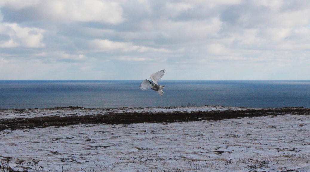
May has been about getting myself back into hiking shape. I started the month by taking Heather out to see Cripple Cove for the first time. There was no talk of rope-assisted climbs or kilometers of dirt road, which Heather tells me would have led to a veto of the activity. It was for the best as this is can’t-miss trail IMHO! Anyhow, we had a heck of a day, saw a bald eagle (or two), one of which chased a smaller, unidentified bird of prey away from a perch which could have been a nest: I consistently see bald eagles near Cripple Cove and so I assumed they were nesting in the area. A few pics from the Cripple Cove leg of the White Horse Path; more hike talk below:

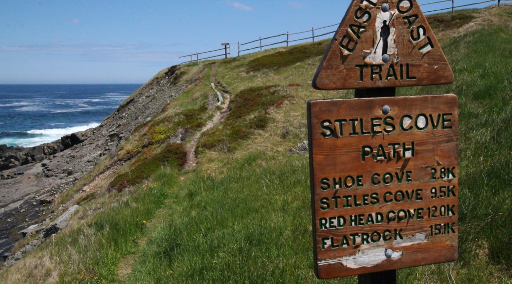
I experienced some knee pain at the end of that hike so along with an exercise/stretch regimen I decided to make the next few flat: my issue is “hiker’s knee,” which flares up when too much strain is put on the knees walking downhill. The next one for me, then, would be the first few kilometers of the Stiles Cove Path as far as Shoe Cove. This is mostly flat with one glaring exception on the approach to Shoe Cove itself. I felt a little tinge but it was a spectacular day and overall my knees held up.

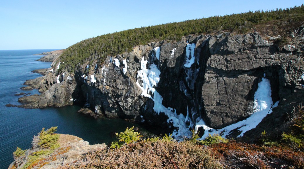
There is a moose carcass at Shoe Cove, it is somewhat decomposed at this point but some folks would probably still find it a little unpleasant. It’s in the middle of the beach and is hard to miss. Kind of sad and gross in this prime hiking destination; I understand that it’s the circle of life etc. but some folks are going to be turned off from Shoe Cove which is sad because IMHO it’s one of the highlights of the ECT. Pics and more discussion below, WARNING, there is a pic of the moose carcass:

Next up was the north end of the Cape Spear Path. I was disappointed to see very clear mountain bike tracks on the trail. Bikes are clearly prohibited on this section of trail and as you can see there is a clear impact on the treadway. I saw bike tracks heading off the trail and into sensitive flora. Not cool.

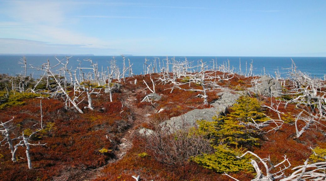
Anyhow, I had never hiked the complete side trail to North Head, and when I got out there I was feeling good, so I checked it out before heading down to Summerside. This is a part of the trail that fascinates me: apparently, there was at one time habitation at this location, complete with its own trail. I have searched and can find no sign of this habitation. It must have been a windswept, difficult location in winter, completely open and somewhat wet in places. In one of the pictures below I have indicated a linear collection of rocks that could be clearing for human activity, a rock wall, or even the base of a building of some sort, but it’s really reaching. There remains little to indicate humans ever resided here. There’s something fascinating about  that to me! A few pics of that hike; and more hike talk below:

Another day, another hike: next up was a tester on the Beaches Path for my new backpack, an Osprey Exos 48, lightweight for the extended trips. I picked mine up at liveoutthere.com, a great little Canadian shop. I packed a couple of things but left it basically empty, wanting to get a feel for it without adding too much weight to strain my knees. I was thoroughly impressed with it. I hadn’t yet removed the Cotton Carrier from my Marmot bag though, so I left the camera home, hence the iPhone pics below.

It was a foggy, chilly day along the Beaches Path, but it made for a crisp hike and some good pictures, and the smell of the ocean was something else. If there’s one smell that brings to mind memories of home it’s the salt air on a cool, crisp day. I breathed it deep as I hiked. There was a fair bit of mud and water along the trail; it was far wetter than I remember it. Perhaps it just needed a few more dry days. More hike chat past the pics:

Last but not least, Saturday started mauzy but turned into a heck of a day for a hike once the sun came out, so I hit Mickeleen’s Path for Saturday afternoon jaunt on another relatively flat trail. There was a  lot of traffic on the trail which is great to see. The treadway itself was much drier than Beaches a few days before, but there was still mud in spots, and for hikers looking to take the loop back to Bay Bulls, the Old Track had a few wet spots as well. These were easy to avoid, however.

Today’s gear test was the first hanging of my new hammock, a Hennessy Hammocks Expedition Asym Zip. I didn’t fully string the rain fly but did successfully lash the thing into place, and then proceeded to nearly fall asleep when testing it out. I packed up the hammock and fly in the “Snakeskin” wraps and put it all away, and left the site with a grin on my face: can’t wait to try the hammock out on an overnight!

Best news of all, which also had me grinning… no knee pain on either of the last three hikes! Fingers crossed that the work I’m doing (exercise/stretching, losing weight, improved trekking pole technique are all partially responsible for the improvement IMHO) continues to bear fruit!

A few pics of the hammock and hike below. Have fun on the trails!

Long Time No Post! Stiles Cove Path Hike and Fallout

Hi folks! Apologies for the lack of posts for the last month or so. Of course this back-to-school experiment has been keeping me busy, and when I’m writing papers I’m rarely in the mood to sit down and write posts, but that’s not all of it. I hurt my knee hiking on the Stiles Cove Path trail about a month ago, and since I haven’t been able to hike much, especially with the beautiful weather we’ve been having, I’ve been too frustrated to blog about hiking. I’m currently in recovery mode: I tried a couple of short hikes, and tested myself with a slightly longer one, and I’m still feeling some pain. I’m continuing to rest and exercise my knee, but it’s frustrating to say the least! At any rate, I do have some nice pics from the last couple of hikes to post, so on to more pleasant fare, and hopefully my knee improves quickly so I can get out there more often to take more pics!

I had a spectacular Saturday for the Stiles Cove Path! I parked in the lot of the church in Flatrock, and got a cab up to the other trailhead in Pouch Cove. I was pretty stoked about getting out on the trail: I had hiked portions of this trail on a number of occasions in the past, but never the whole thing; there was a section of five or six kilometers in the middle of the trail that I had never seen before, including the trail’s namesake.

The cutaway section a km or two from the Pouch Cove trailhead has gotten larger. I’m not sure what the point of all that destruction is, but some forward thinking might have been in order: if they’re planning residences, there are folks like me who actually like having trees on our property, and we’re the type who would gladly share our property with the ECT. And as for things I comment on whenever I hike this section of the trail, that strange metal mesh object is still in the woods approaching Shoe Cove. Weird.

I was climbing down the hill towards Shoe Cove, just coming off the steps, when I heard someone frantically calling a dog. I quickened my pace and hurried towards the river at the bottom of the hill, and the frantic shouting continued from the other side of Shoe Cove, from the trail as it descended towards the cliffs of the cove. Suddenly, I saw a big, fat chocolate Lab chasing something through the woods at the edge of the cliff, and then back towards the trail. By the time I got to the bridge, the dog had rejoined his frantic owner on the trail and was approaching me, breathless, from the other side of the river. I stopped and chatted with him while they both caught their breath. I’m not sure what the dog was chasing, but it was big enough that I thought it may have been another dog; I asked, but it was just the two of them, so a fox or a coyote, perhaps? At any rate, that was very close to a disaster, folks: the ECT can be a very dangerous place for animals, and it’s best you keep yours on leash!

At any rate, I was treated to some spectacular weather and scenery. The trail is spectacularly beautiful from start to finish, and at 15 km, it’s certainly something most relatively-in-shape hikers can accomplish in a day. I certainly wasn’t worried about it. I started feeling some knee pain at the 7 or 8 km mark, though. I had felt this particular type of pain before, and wasn’t too worried, but by the time I was approaching the last couple of kilometers of hiking, I was in significant pain, and had no other choice but to finish the hike. Uphill hiking was fine, but downhill was painful, and steps were agony. And this trail basically ends with steps. I grinded the last couple of kilometers out but I wasn’t feeling good by the time I got back to my car.

I’m starting to feel better, at any rate, and I did get to see some spectacular trail! I managed to snap some great pics to add to my collection from along this trail. Check them out!

The End of the ECT Snowshoeing Season?

Despite the beautiful, cloudless sky, I found it hard to get motivated to head out for a long hike yesterday. Deciding on a short snowshoe into Shoe Cove along the Stiles Cove Path out of Pouch Cove, I strapped the snowshoes to my pack and headed out. The first part of the trail, alongside the ocean, was free from snow. So far so good. I kept expecting to see snow as I rounded each corner, but the trail was basically clear! Instead of a short jaunt to Shoe Cove, I made far better time than I thought I would due to the lack of snow, and so I continued onto Blackhead Cove before doubling back and heading back to Pouch Cove for a nice little 10k hike. My snowshoes stayed strapped to the pack the whole way.

Once I was on the trail I was glad I had gotten out. Not a cloud in the sky and no snow on the trail, the scenery was simply spectacular. I was so surprised to find the trail free of snow after the difficult trekking of the last two weeks that I was almost running the trail. I made such good time that ended up covering twice as much ground as I figured I’d end up snowshoeing.

On the return trip, climbing the hill out of Shoe Cove, I could hear ATVs coming down the Shoe Cove Road path. So much for the peace and quiet of the trail, but I guess there’s not much to be done about it since the ECT heads close to many towns. They didn’t have to be quite as obnoxious as they were, though, spending the next 20 minutes or so driving through the gut of the Shoe Cove river over and over:

I heard them tearing around the community as I made the return trip, but for the most part they were far enough away that I was in relative peace and quiet for the majority of the return trip.

Spectacular hiking! I suspect that there’s still snow on some of the Southern Shore legs of the ECT, but if Stiles Cove is any indication, the hiking season has officially begun on the ECT! Check out some of the pics below!

The Snowy Owl Invasion of 2013

Hi folks! I got a question about the pic of the Snowy Owl above, taken at Red Head on the Stiles Cove Path trail of the East Coast Trail. This was a late fall hike, snow was on the ground, as you can tell, and we came out of the woods to find a pair (male and female) of Snowy Owls. We stood back and took a few pictures as best we could (I had left my zoom lens at home so I did what I could with my 18-55mm), and the owls obliged us by flying close by a couple of times. We didn’t stick around for long, thinking they were probably stressed by our proximity, so we made a wide berth around them… a little too wide, because we ended up taking a community path away from Red Head and getting sidetracked by a half hour or so!

We had heard about the “Snowy Owl Invasion of 2013”, and this was our encounter with it! You can read more about the Snowy Owl Invasion at this link. Bruce Mactavish, the article’s author, is a local birdwatching expert.

The best of the pictures I took that day can be found here, on my Tumblr. Cheers!