Post-wise, things may have been quiet, but I haven’t stopped hiking! I accomplished a few hikes that I haven’t posted about. My memory isn’t as sharp as it once was so I can’t give you much detail about the trails, but the pics are here, at least… I always take my camera the first time I hike a trail!
In July of last year, I hiked the Mudder Wet Path and the Spurwink Island Path as a pair, camping out overnight on the Spurwink Island Path at the Gallows Cove campsite. Here are a few things about this hike:
1. The map looks a little confusing for the Mudder Wet Path, but it’s a straightforward, easy to follow, and very scenic hike. The confusion lies with the route of a highly recommended side trail following Little River to a waterfalls. When I hiked it, the staircase down to this side trail was being worked on. The main trail is a pretty woods path above the river.
2. Berry Head is the highlight of the Spurwink Island Path. I honestly don’t remember a heck of a lot about it beyond that other than it being a spectacularly scenic walk, and that my knee died again about midway through and I was pretty wiped out by the end of the hike. This trail needs a rehike!
Anyhow, here are a few pics of those trails… more after this gallery:

The trail starts with an ATV path from the end of Riverhead Road in Aquaforte.

The wide path remains so for the length of the trail.

Little River opens to the bay.

The new stairs to Little River and the falls.

The falls at the end of the Little River side trail.

The main trail passes directly above the Little River side trail.

The trailhead for the south end of the Mudder Wet Path is next to the trailhead for the north end of the Spurwink Island Path, behind a structore on route 10.

The trailhead for the more strenuous Spurwink Island Path.

The hike begins crossing an old overpass.

The march at the beginning of the hike is rich with Pitcher Plants.

Planks cover the initial, marshy section.

White Horse River.

White Horse River.

The sections of this trail through the woods are pretty.

Croft’s Meadow.

Not much of a view at Bruin Cove.

Gallows Cove, the site of the camp!

I think this is breaking down the next day.

Heading out past the sign.

The viewpoint for Spurwink Island.

South Head with Spurwink Island barely visible behind.

Heading away from Spurwink Island.

Looking ahead at Little Gallows Cove.

Little Gallows Cove.

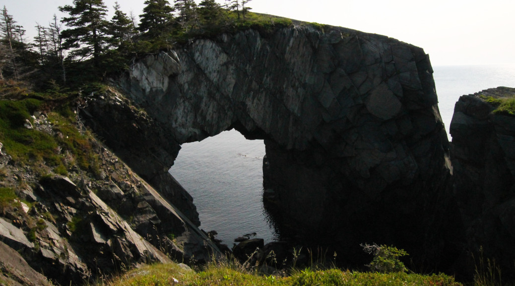
The view from atop the Berry Head Arch, looking at the signage… it’s the tiny white sign in the distance!

Looking along the coast from the arch.

Geologically the arch is fascinating.

The arch from the sign.

The aforementioned sign.

This little frog let me get very close.

A view north along the coast.

Lawler Bay.

Lawler Bay?

Founder Cove.,

Founder Cove? Or Chance Bay?

Chance Bay.

Grassy Point. Aptly named.

Bald Head. Also accurate.

I was too lazy to walk back to the trailhead when I realized I had forgot to take a snap of it.
Deadman’s Bay Path:
It had been a slow fall for hikes but one chilly day in early December I decided my knee had gotten enough rest. With the snows looming, squeezing in one last pre-snowshoe hike seemed like the thing to do, and cluing up the northern end of the ECT was an awesome accomplishment to end the year with!
The trail starts with a pretty significant climb, and it was icy, as you can see in the pictures below. I hiked it fast trying to keep up with another hiker (competitive streak, guilty) and was huffing and puffing by the top with full pack weight (I thought I could strengthen my knee by working it out with extra weight). I have since learned that going light and fast is a much more effective way to strengthen my knees.
From the top of the initial climb, much of the trail passes over the sparsely vegetated South Side Hills, dotted with small ponds and erratics. It was a chilly day and the still ponds were icing over. Descending to Freshwater, a bit of ice was forming on the Barachois. If you haven’t seen it, it’s another one of the jewels of the ECT: just a spectacular site to behold. I headed across and took a quick break to snack and rehydrate before getting back on the trail: the best way to keep warm on days like this is to keep moving.
By the time I got to Peggy’s Leg I was experiencing a bit of knee pain. Ugh. I was starting to feel like this was going to be a long-term issue.
No need to end on that note, though; check out these pics!

Pretty interesting signage!

A bad sign: the first steps were covered in ice.

One of the ponds atop the South Side Hills. Fall colors.

Iced over.

Soldier’s Pond.

A spectacular calm day.

Duck Pond, no ducks.

Coming around a corner, the first view of the Barachois at Freshwater Bay is something else.

Ice starting to form on the Barachois.

The trail here consists of the flatter, larger rocks.

The wreckage of something.

The river crossing is easier than it looks.

Looking north.

One of the jagged rocks visible from the trailside as it approaches the Blackhead end.

Peggy’s Leg.

Peggy’s Leg.

Check out the frost growing sideways from the wood!