Tag Archives: Newfoundland

First Hike of the Spring!

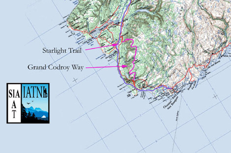
The first day of spring was two days ago, so that means the spring hiking season has begun! It’s still snowshoe season for the most part on the trails of Newfoundland, at least, especially in the woods. Given that it was going to be a bit breezy for Saturday’s hike, I decided to hike a section of the trail that had significant amounts of inland/wooded hiking, Tinkers Point Path. The trail was snow-covered and required snowshoes, but it was in such great shape that I’m sure it could mostly be negotiated in boots. At some point this winter a group of hikers traversed this path and beat down a spectacular track with their snowshoes; so good that for most of the Path it reminded me of the groomed snowmobile trails around St. Anthony on the Northern Peninsula!

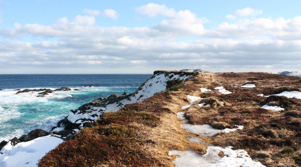
The first section of the trail starts a little rough (I assume it gets a lot of use) but quickly settles into the “groomed trail” that covers 90% of the distance between Mobile and Tors Cove. The first bit, with the fence on one side and the coast on the other, has one spot that requires hikers take care; hug the fence and you’ll be fine. Exiting the woods for the first time, Marshy areas are starting to open up. The snowshoe trail in spots crosses areas that are becoming wet, so be careful. That said, sticking to it for the most part is safest: I deviated from it only a couple of times, and paid for it when I went through into a wet spot on the hike back.

Plenty of snow remains in the woods, but open areas such as Tinkers Point and Vales Meadow are pretty much free of snow aside from the established path where the snow was compacted. Speaking of Tinkers Point, the seas were very rough today, and crashed spectacularly against the rocks just off Tinkers Point. The section of the trail between Vales Meadow and the inland trek towards Tors Cove was very noisy with crashing waves. In a couple of places, a mini spout effect was created as water shot straight up against a barrier. Check out my pics!

I turned around at The Cribbies as per my agreement with Heather: I was not to snowshoe over the trail as it passes behind the fish plant in Tors Cove, a section with a precipitous drop. The Cribbies is close enough to the trailhead, I suppose!

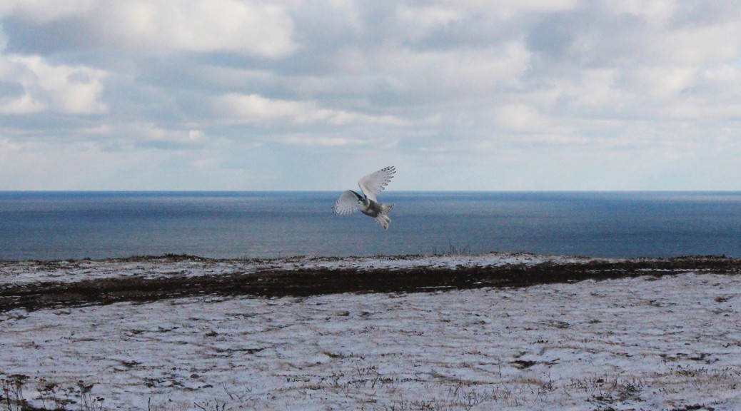
I saw signs of wildlife, many gulls, a few small birds including juncos, and two bald eagles, one at either end of the Path. I got snowed on as a brief flurry passed over, but the weather was nice for most of the hike, with the sun coming out for the return trip. It was warm enough that I kept my jacket packed and my gloves off. I highly recommend this trail as a relatively easy spring snowshoeing adventure! Check out the pics below, and in the Tinkers Point Path page’s gallery!

A Late Winter Hike at Cape Spear!

I’ve been on mid-term break all week and itching to get out for a little hike, but the weather has been uncooperative: I’m not one for extreme cold weather, and with wind chills dipping into the -30C range, I was waiting it out. Friday started promising, warming but windy, and knowing that I’d only be out for a couple of hours, I waited for the later part of the afternoon, when the temperature got up to -4C. It was still pretty windy, but once I got into the shelter of the woods at the start of the Cape Spear Path, it was a wonderful snowshoe trip! My goal was Staffordside, or at least the branch that leads to the valley, but I left it too late, and given my lack of exercise this winter, it was probably for the best… snowshoeing is hard work at times! I turned around as the path climbs the ridge over Sharks Point at about the 4 km point (the parking lot where I started is about at the 1.1 kilometer point). 5 or 6 km in the bright sunshine through the snowy woods!

I saw a few interesting birds of prey including a snowy owl who I scared up from some rocks just past the lighthouse. I fumbled with the zoom lens with mittened hands and didn’t get it on in time to get a good shot of him. Afraid that’d happen again, I hiked out to my destination with the zoom attached and switched to the more landscape-friendly 18-55mm for the return trip. A pair of eagles flew overhead as I descended the hill to the parking lot: even without the zoom lens, they came close enough for me to get a couple of nice shots!

Pics below and in the Cape Spear Path gallery!

The Snowy Owl Invasion of 2013

Hi folks! I got a question about the pic of the Snowy Owl above, taken at Red Head on the Stiles Cove Path trail of the East Coast Trail. This was a late fall hike, snow was on the ground, as you can tell, and we came out of the woods to find a pair (male and female) of Snowy Owls. We stood back and took a few pictures as best we could (I had left my zoom lens at home so I did what I could with my 18-55mm), and the owls obliged us by flying close by a couple of times. We didn’t stick around for long, thinking they were probably stressed by our proximity, so we made a wide berth around them… a little too wide, because we ended up taking a community path away from Red Head and getting sidetracked by a half hour or so!

We had heard about the “Snowy Owl Invasion of 2013”, and this was our encounter with it! You can read more about the Snowy Owl Invasion at this link. Bruce Mactavish, the article’s author, is a local birdwatching expert.

The best of the pictures I took that day can be found here, on my Tumblr. Cheers!

Starting the Spring/Summer Hiking Plan!

Hi folks! I sent off my membership application for the International Appalachian Trail, Newfoundland and Labrador chapter today! Pretty exciting stuff. I’m looking forward to getting access to the maps and GPS tracks that come with membership. I’m still undecided as to which course to take for my “big” hike this spring/summer, but one or more of the trails along the IATNL route is a strong possibility… I was thinking that I might hike the Grand Codroy Way, Starlight Trail, and then take the IATNL long distance route to Stephenville, if such a thing is feasible… can’t wait to get the maps in hand and figure it out! Anyhow, that’d be about 200 km, so a week or two of solid hiking. It promises to be an incredible experience.

The other possibility I batted around is a through-hike of the East Coast Trail… it’s almost 100 km longer than the IATNL option, but I’d be home for at least one night when the trail passes through St. John’s… decisions!

Whichever “big” hike I take on, I’ll be doing my warmup hikes on the ECT… I have yet to do the Motion/Spout twosome (for shame!) so that’ll be very early in the season… first chance I get with camera-friendly weather!

All credit for the above image goes to the IATNL. You can see the full version on their webpage!